![Item #1929 [CONFEDERATE MAP]. Positions Along the Potomac River, South of Washington, D.C., to Fredericksburg, and West to Centreville, Manassas, and Stafford Court House in a manuscript map, captioned "A Sketch of our present location at Beeria No. 1, Prince William Co., Virginia! and surroundings!!"](https://tombergrarebooks.cdn.bibliopolis.com/pictures/1929.jpeg?width=768&height=1000&fit=bounds&auto=webp&v=1638060098)
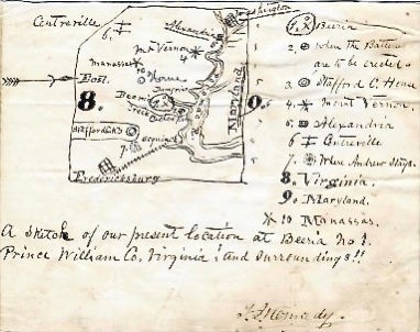
[CONFEDERATE MAP]. Positions Along the Potomac River, South of Washington, D.C., to Fredericksburg, and West to Centreville, Manassas, and Stafford Court House in a manuscript map, captioned "A Sketch of our present location at Beeria No. 1, Prince William Co., Virginia! and surroundings!!"
Prince William Co., VA, [ca.1861]
[CONFEDERATE MAP]. KENNEDY, Thomas Jefferson. Picturing positions along the Potomac River, south of Washington, D.C., to Fredericksburg, and west to Centreville, Manassas, and Stafford Court House in a manuscript map, captioned "A Sketch of our present location at Beeria No. 1, Prince William Co., Virginia! and surroundings!!," and signed by him.
Manuscript map, 3 x 3 inches on a larger sheet of paper (5 1/2 x 7 inches), undated [ca. 1861], ink on lined paper (mounted on stiffer paper), with a key to ten place names in the right margin. Some soiling else very good.
Kennedy's camp at Beeria ('No. 1" on his key) lay between Dumfries and Cedar Run, at the mouth of which Kennedy has noted the site "where the Batteries aree to be erected." Kennedy began the war as a private in the Sumner Country Greys and later served as surgeon to the 2nd Tennessee Infantry and was with his unit at First Manassas and Shiloh.
Item #1929.
Price: $750.00